Welcome to Breakfast in America
I’m a Brit who unexpectedly emigrated to the USA in 2008, and this is my photo journal.
It’s an eclectic mix of things; there’s no guiding theme or topic. It is whatever catches my attention, what I’ve been thinking, doing, or piques my interest. Currently that’s mainly backpacking and clearing some of the backlog on my ‘honey-do’ list.
Popular posts
Trending pictures and short posts.


Popular pages
Trending longer content.


Memories
A dozen pictures, picked at random from my favorite memories. You can see my portfolio here.

Meanwhile, here are some kitties

Crystal Bridges’ Art

Ocean Zen

Little Sac River, near Willard, Missouri

The Little Mermaid – Springfield Little Theater

Sunset Glow

Font and Flag

KFC at the Pompey Centre, Portsmouth

Woodland pond in the last of the day’s sun

Sunset – Cedar Ridge, Stockton Lake, Missouri (#2)

Stripes — View from our hotel room

Kauffman Center For The Performing Arts, Kansas City
Recent Posts
-
Tree down across Little Brazil Creek

Tree down across Little Brazil Creek. The Berryman Trail, December 2024. Copyright © 2024 Gary Allman, all rights reserved. The top of this tree landed right where I had been thinking about setting up camp. That ain’t going to work. Plenty of water to top up my supplies though.
-
Stopped for lunch at Little Brazil Creek

Stopped for lunch at Little Brazil Creek. The Berryman Trail, December 2024. Copyright © 2024 Gary Allman, all rights reserved. I arrived at this primitive campsite by Little Brazil Creek at one-forty. Since the Survey Marker, I’d met a group of eight day-hikers heading south on the trail. We didn’t stop to chat, so I have no idea where they started their day, or where they were heading.
Lunch was noodles and a cup of Ginger and Orange tea, plus some nuts, M&Ms and rasins.
I felt fine. I had been taking it easy, hiking slowly and stopping regularly. The spot where I camped when I last stopped here was not going to work, as two trees had fallen pretty much right on it. You can see one of them in the background of this picture. There was also a lot of noise coming from ATVs/Side-by-sides having fun to the south where there’s a forest road to Hamon Spring, and then along and up along the ridge near this spot. That decided me to load up with water and head on to a spot well off the trail nearer to Brazil Creek.
All cleared up after lunch and ready to move on

There are lots of trees down — but I only saw one down across the trail that had not been cut away. All cleared up after lunch and ready to move on. The Berryman Trail, December 2024. Copyright © 2024 Gary Allman, all rights reserved. -
Witness trees and survey marker

Witness trees and survey marker. The Berryman Trail, December 2024. Copyright © 2024 Gary Allman, all rights reserved. This survey marker is located at a point where the trail runs just a few yards from FR2436 (to the right as I took this picture. You can just make it out at the top right of the frame). It was around here that I encountered my last cyclist of the day. 🙂
-
The trail is well-maintained and skirts around the hollows

The trail is well maintained and skirts around the hollows. There are a lot of hollows on this trail. The topography is very crinkley; the hollows steep and deep, but the trail is very well graded. The Berryman Trail, December 2024. Copyright © 2024 Gary Allman, all rights reserved. This is a view of the trail looking north, just north of where it crosses FR 2274. I spotted a chipmunk on the trail a few minutes earlier, but it ran off too quickly for me to get a picture. That’s a shame because I very rarely get to see chipmunks. Look carefully, and you can see the trail in front of me taking a right into the hollow. You can make out its line behind the trees as it winds back out again. FR 2265 (aka Floyd Tower Road) is on top of the ridge, so it’s very close.
I crossed FR 2265 around midday. I’d just checked my ECG and it was fine. I met two cyclists at the crossing. One of them quizzed me on my Bedrock sandals. Before we could continue chatting, seven cyclists came up the trail behind me. I left them to it and carried on. A few minutes later, the seven cyclists overtook me.
In this section of the trail, there has been some significant thinning/harvesting of the trees, which explains all the blazes I saw on the trees back in 2020. It makes the forest look very ‘thin.’ Another thing I’d noticed, was, like all the other Ozark trails I’ve been on this year, there was a huge number of trees down. The difference on the Berryman Trail is that nearly all the trees that fell across the trail have been cleared. I only saw one tree across the trail in the entire twenty-seven-plus miles.
-
Day Two, breaking camp

Day Two, breaking camp. The Berryman Trail, December 2024. Copyright © 2024 Gary Allman, all rights reserved. And once again I forgot to take a picture of my campsite. At least I remembered before I’d taken the tarp down. I camped a couple of hundred yards southeast of the spring at the former Edward Beecher Recreation Area.
Decision Time
I checked my ECG when I woke up, and it was clear. That was good.
I double-checked my heart rate while I was hiking yesterday and confirmed that it was low. I maxed out at 129 BPM. I was well hydrated, so why had I gone into AFIB? Well, that was puzzling, but there was nothing I could do about it. Now what to do? I had several thoughts overnight.
- I’ve never had a second bout of AFIB immediately after it’s cleared. If I carried on, maybe, at worst, it would reoccur on Day Three, by which time I’d already be heading back towards the trailhead. I had one extra pill left, and normally, that would be enough to bring it back under control.
- There are many forest roads crossing the trail. If I needed to bail out, I could use them as a shortcut back to the trailhead and, if I was lucky, hitch a lift.
- I was sure missing a couple of days of the coated Aspirin would not significantly change my blood’s clotting ability.
- I could cut my hiking speed considerably and take things a lot easier on the trail with frequent stops.
- Today was going to be my shortest mileage day, so if I went further, I could cut down on the distance I had to travel the following two days.
- Of course, I could take the most sensible option and head straight back to the trailhead.
I checked the map, and found a flat area on a ridge to the north of the trail between Little Brazil Creek and Brazil Creek that would make a good place to stop. It would push the day’s mileage up from five-and-a-half miles to more like seven, but I could make that decision when I got to Little Brazil Creek.
Stubborn Gary took over, and I decided to carry on. I’d regret it if I went home without at least trying to get further along the trail. Once I was hiking, I’d check my ECG again, and if there was any sign of a problem, I’d turn around immediately and head back to the trailhead.
By ten-fifty, I was packed and ready to get on the trail. I’d heard a couple of horses go by, and that was it. I headed down to the spring, grabbed enough water to last me until lunchtime, and headed north toward Little Brazil Creek.
-
Berryman Trail — Day One stats and a packing omission

At two forty, I passed the 6.5-mile marker and arrived at the Edward Beecher Campground just after three. I filled up with water for the night from the spring. With four liters in hand, I backtracked a couple of hundred yards down the trail to a low ridge I’d noticed on the way in, to the east of the trail.
It looked like a good spot, and I found some trees that would let me set up camp with my hammock across the wind. While I was making camp I heard an ATV stop at the spring and then continue up the forest road that passes through the abandoned campground. I was glad I’d decided to camp well away from the road and spring.
The “Bad Decisions make Good Stories” patch on my backpack was silently mocking me
Camp sorted, I ran an ECG, which informed me I was in AFIB. It must have been very mild bout, as I could hardly feel it, but it confirmed my suspicions. I immediately took one of my pills, and then the extent of my potential problem dawned on me. I usually pack a couple of extra pills to cope with a bout of AFIB. But this was Day One, if I had AFIB every day, I didn’t have enough pills with me to keep it in check — assuming it responded. Also, I’d somehow managed not to pack enough of the coated Aspirin tabs I take each day to reduce the risk of a stroke from AFIB (I don’t take more aggressive anticoagulants because of the amount of scratches and gouges I get backpacking).
This was a dilemma. Should I turn around and go home in the morning? Carrying on would take me further from the trailhead.
The “Bad Decisions make Good Stories” patch on my backpack was silently mocking me. I decided to sleep on it and see how my heart was behaving in the morning. If I was to carry on, I would have to come up with a way of mitigating the risks.
-
Trail Signs

The Berryman Trail forms part of the Ozark Trail, and the entire loop is looked after by the Ozark Trail Association, and a very good job they do too. The Berryman Trail, December 2024. Copyright © 2024 Gary Allman, all rights reserved. 

Day One
For once, I was ready to get on the road before nine. That was just as well, as it’s 160-miles to the Berryman Campground and Trailhead.
By the time I was ready to get on the trail, it was eleven forty-five, overcast, and damp. I wanted to get to camp well before dark to find a spot reasonably close to the trail and spring, but far enough away not to have to deal with or be seen by anyone.
After taking some pictures of the trail signs, I set off at a fast pace (for me). I kept a check on my heart rate, which didn’t go above 130 BPM, which was good.
I love how this trail winds in and out of the hollows through the mixed oak and short-leafed pine forest.
The trail was just as I remembered it: an easy-going surface that is great for bikes and hikers alike, easy to follow despite the leaf-off, and with regular Ozark Trail blazes and Berryman Trail mile markers. However, it would seem that many blazes and mile markers have been damaged or destroyed by animals chewing on them and the effects of wildfires and prescribed burns.
I love how this trail winds in and out of the hollows through the mixed oak and short-leafed pine forest. It makes for a much more interesting hike than, say, the Whites Creek Trail, which features long straightish runs through oak woods with little variation. The inclines are generally easy with well thought out switchbacks that make keeping up a good pace simple.
I noticed my heart was skipping every now and then
A couple of hours into the hike I took a break for a drink and snack, and I noticed my heart was skipping every now and then. I’ve recently adjusted my meds, and my heart has not been running as fast during exercise and has been recovering (slowing) more quickly since the change. I had run over three miles twice earlier in the week with no ill effects, so I was confident I was fit enough to hike at a respectable speed. My watch heart alarm hadn’t triggered either, so I decided to press on regardless and run an ECG check once I’d found a place to camp.
-
Berryman Trail Mile Marker

First .5 Mile Marker. The Berryman Trail, December 2024. Copyright © 2024 Gary Allman, all rights reserved. There’s a couple of problems with the trail markers and blazes. First the wildlife likes to chew on them, and second, they curl up when they get heated by prescribed burns/wildfires.
-
Gary at the start of the Berryman Trail — Berryman Campground, Missouri

The start of the Berryman Trail — Berryman Campground, Missouri. The Berryman Trail, December 2024. Copyright © 2024 Gary Allman, all rights reserved. This will be my last backpacking trip of 2024. I’m nowhere near my goal of hiking 240 miles in 2024, but I’ll be spending the next four days hiking the twenty-seven-mile Berryman Trail near Potosi, Missouri, which will get me a bit closer.
The Berryman Trail

I’ve hiked the Berryman Trail twice — in 2011 (clockwise) and 2020 (counterclockwise). When I hiked it in 2020, the trail had been substantially rerouted and extended to its current length of twenty-seven-odd miles. In 2011, it was 24 miles. On my last visit, it was in excellent condition, well-graded, blazed, and easy to follow. That will make a nice change from the Whites Creek Trail in Irish Wilderness!
The trail runs through short-leaf pine and oak forests and generally follows the contour lines into and around the hollows. You’ll enjoy this trail if you like the Ozark’s crinkly bits with deep hollows. The Berryman Trail is not in a designated wilderness and is open for hikers, equestrians, and cyclists. Motor vehicles are not allowed on the trail but can be encountered at the trail’s many forest road crossings.
The trail is divided into east and west segments. When I last hiked it, water was available on the West Segment at the spring at the abandoned Beecher Campground, Harmon Spring and Trailhead, Little Brazil Creek, and Brazil Creek. The East Segment has a reputation for being dry — I’ve seen caches of water at the point where the trail crosses Floyd Tower Road. However, I have found a low-output spring on the trail a mile or two south of Floyd Tower Road.
According to signs at the trailhead, logging and road-building operations are in progress to the south and west of Berryman Campground.

Logging and road building — but it’s all to the south of where I am heading. The Berryman Trail, December 2024. Copyright © 2024 Gary Allman, all rights reserved. 
Logging and road building — but it’s all to the south of where I am heading. The Berryman Trail, December 2024. Copyright © 2024 Gary Allman, all rights reserved. Weather
The weather should be warmish, mid-thirties to mid-fifties, mostly overcast, and there’s even some overnight rain in the forecast. There will be some gusty winds on a couple of nights, so I’ll need to pay attention to how I set up my hammock.

The above image is courtesy of my subscription to windy.com (Check out the free version, it is the best weather site I’ve found. If you are a weather nerd, subscribe! I’m not an affiliate; I just want to see them remain in business).
Gear
Basically, I’m going with the same gear I took on my recent Irish Wilderness hike: my summer quilts and tarp, backed up by winter clothing, just in case it turns chilly. This will allow extra water to be carried, if necessary, on the East Segment. This time, I remembered to pack my Pop-Tarts, and I have a nice thick book to keep me occupied through the long dark evenings.
I’ve swapped out my LED light string for my LED camp light. It’s much quicker to set up and put away, and I want to see if I miss the light string.
The Plan
Dawn is around seven-thirty, and sundown is around four-fifty, so daylight is in short supply.
- Day One. I’m hiking the trail clockwise, so my stopping point will be the abandoned Edward Beecher Campground with its handy spring. As that’s some seven miles from the trailhead, I’ll need to get moving to get there before dark.
- Day Two. My shortest day, at around five and a half miles. I’ll hike to Little Brazil Creek and camp there somewhere, probably on the ridge to the west of the creek.
- Day Three. My longest day of over eight miles. Hike to Brazil Creek Campground, top up with water for the East Segment and the remainder of the trip. I’ll stop at the spot where I camped on the first night of my previous visit.
- Day Four. Hike the remaining six miles back to the Berryman Campground Trailhead.
-
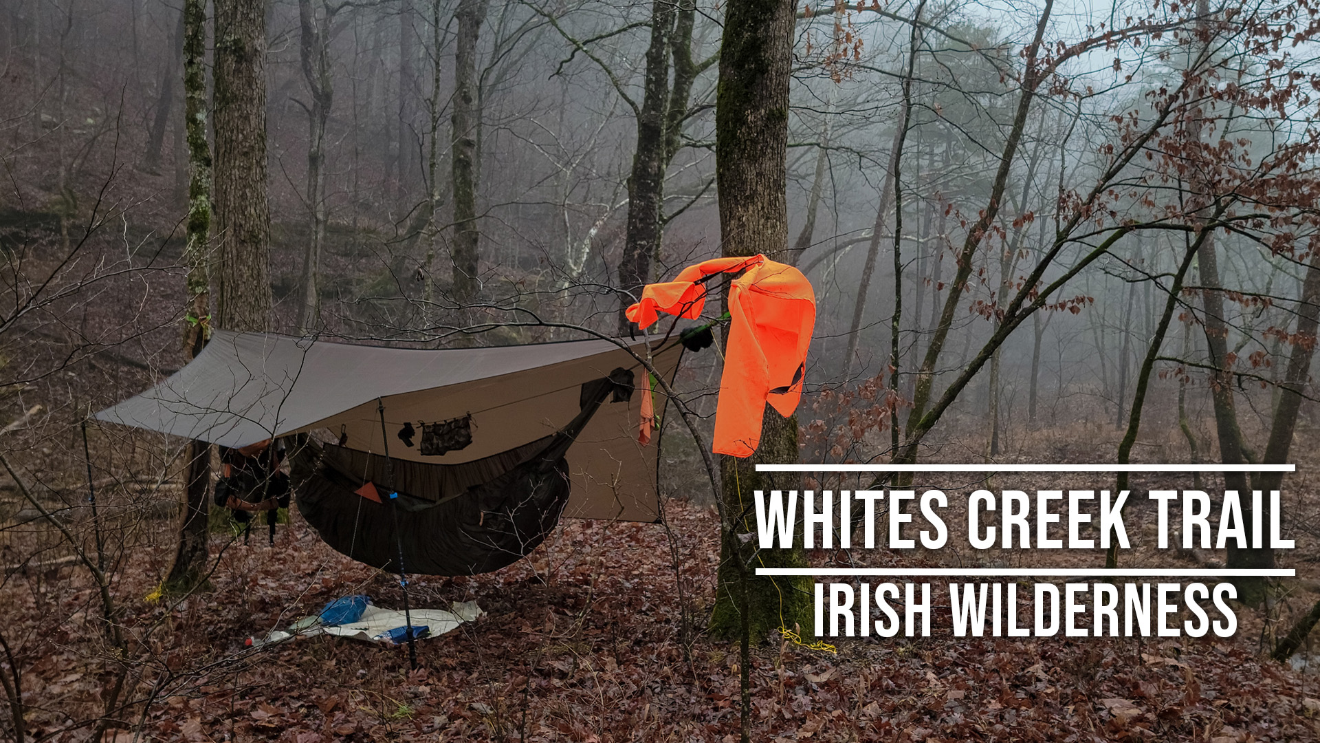
Journal: Four days hiking the Whites Creek Trail, Irish Wilderness. December 2024

There’s a break in the weather and even some rain in the forecast. I’m going to Irish Wilderness where I’ll hike the Whites Creek Trail counter-clockwise, and I’m going to take a leisurely four days to do it.
For details of this trip